Posts

Showing posts with the label GPS solution

Bus tracking Technology and Thai public transportation

Image
On any given day in Bangkok, Thailand, you can find more than 20,000 buses, minibuses, and vans operating on 470 routes. In a city of 8 million people with another 14 million in the greater Bangkok Metropolitan Region, public transportation is a necessity. Unfortunately, public transportation can also be a great liability.  GPS technology in public transport not only functions as a tracking device. It is also a form of deterrent to unsafe road practices. A bus driver will take more precaution and adopt road safety measures knowing that their vehicular usage is being constantly monitored.   Zero accident in public transportation can come to reality as in the beginning of 2016, Department of Land Transport has enforced all new-registered public transportation, trailers and lorries with 10 wheels or more to install  Vehicle GPS Tracking Device  . All data is linked to Department of Land Transport’s Transport Management Center to accommodate tracking and observe dri...

Making Tracks with personal GPS tracking devices

Image
Remember the story of Hansel and Gretel, the kids who dropped breadcrumbs in the forest to try to find their way back home? Their story would’ve had a different ending if they had a GPS receiver because all newer GPS receivers leave electronic breadcrumbs (called tracks or trails depending on the manufacturer) while you travel. Every so often, the GPS receiver saves the coordinates of the current position to memory. This series of tracks is a track log or track history. (Because various GPS models handle tracks differently, check your user manual for specific details.) Note these differences between tracks and waypoints: Names and symbols : Although tracks and waypoints are both location data points, tracks don’t have names or symbols associated with them and can’t be edited in the GPS receiver.   Autocreation: Unlike waypoints  — that you need to manually enter — tracks are automatically created whenever a GPS receiver is turned on (that is, if you have the tr...

The value of GPS technology to Autonomous navigation systems

Image
True navigation, which provides the user with detailed instructions on how to reach a specific destination, is one of the fastest-growing areas in intelligent vehicle technology. Navigation devices utilize map-matching and best-path algorithms, along with userdefined filtering, to allow the user to choose between the fastest or most direct route to a desired destination. Some systems even allow the user to indicate specific routes to be avoided. The map databases used all provide basic mapping information (streets, major landmarks, etc.), but can also include points of interest and/or helpful location information (restaurants, etc.), depending upon their level of detail and how often they are revised.   Autonomous navigation devices range from in-dash units that are small enough to fit into a 1-DIN slot, to multi-component systems with CD-ROM changers and large multi-plane colour displays. The price of these systems can vary from a few hundred dollars to several thousand doll...

The development tools available for tracking device

Image
The development tools available for GPS application design vary depending on the complexity of the target system and the GPS solution being used. Most  GPS tracker  vendors offer software tool suites that allow a developer to communicate with the GPS receiver through the serial port of a personal computer. These software tools typically use messages compatible with the standard NMEA (National Marine Electronic Association) format, but many vendors also offer their own customized sets of messages and message formats.  The more advanced development tools, available for some GPS chip sets, are intended to help the application developer integrate their software with the GPS tracking software running on the same MCU. Because of the hard real-time constraints typical of GPS software implementations, the most efficient way to enable the smooth integration of the  GPS tracking platform  with the application software is through a clearly defined software API. With a sta...

Some common antennas used for GPS applications

Image
GPS receivers are composed of three primary components: the antenna, which receives the radio frequency (RF) broadcasts from the satellites; the downconverter, which converts the RF signal into an intermediate frequency (IF) signal; and the baseband processor or correlator, which uses the IF signal to acquire, track, and receive the navigation message broadcast from each SV in view of the receiver. In most systems, the output of the correlator is then processed by a microprocessor (MPU) or microcontroller (MCU), which converts the raw data output from the correlator into the positioning information which can be understood by a user or another application. The sections below provide an overview of the three key components of a GPS receiver, describing in generic terms the functionality and capabilities typically found in these systems. As the capabilities of the MPU or MCU needed to process the correlator output is largely dependent on the needs of the applications and the particular...

GPS Solution - How to increase the accuracy of your location

Image
Calibration Electronic compasses need to be calibrated whenever you change batteries. If your  GPS Tracking Device  has an electronic compass, follow your user guide’s instructions to calibrate it. Usually, this requires being outside, holding the GPS unit flat and level, and slowly turning in a circle twice. Altimeter The elevation or altitude calculated by a GPS receiver from satellite data isn’t very accurate. Because of this, some GPS units have altimeters, which provide the elevation, ascent/descent rates, change in elevation over distance or time, and the change of barometric pressure over time. (The rough-and-ready rule is that if barometric pressure is falling, bad weather is on the way; if it’s rising, clear weather is coming.) Calibrated and used correctly, barometric altimeters can be accurate within 10 feet of the actual elevation. Knowing your altitude is useful if you have something to reference it to, such as a topographic map. Altimeters are useful...

GPS tracking solutions - the basic science behind GPS

Image
Fundamentals of satellite-based positioning To understand the true value and cost of the positioning capabilities of the GPS, it is important for the user to have a basic understanding of the science behind positioning, and the types of components and techniques that may be used to calculate accurate positions. The basic science behind GPS; the different unassisted and assisted position calculation techniques that may be used, depending upon the needs of the specific application; and the hardware and software components necessary for calculating a position. The basic science of global positioning The design of the  electronic tracking devices  makes it an all-weather system whereby users are not limited by cloud cover or inclement weather. Broadcasting on two frequencies, the GPS provides sufficient information for users to determine their position, velocity and time with a high degree of accuracy and reliability. As mentioned previously, frequency L1 is generally...

GPS Tracking Solution - Basic GPS Receiver Features

Image
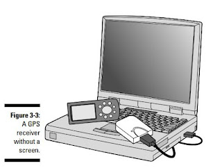
A number of GPS receivers are on the market. Usually a GPS receiver with more features costs more. GPS manufacturers have done a pretty good job making user interfaces easy to use. After you know the basic concepts of GPS receivers and are familiar with a manufacturer’s user interface, a electronic tracker is usually as easy to use as a cellphone and easier to use than a personal computer. Display and output GPS receivers have three choices for information display or data output: Monochrome LCD screen: Most GPS receivers have a monochrome liquid crystal display (LCD) screen. Color screen: These are especially useful for displaying maps. Color screens usually have shorter battery lives than monochrome ones. No screen: Some GPS receivers only transmit data through an expansion slot or a cable; a receiver with a cable is often called a mouse GPS receiver because it resembles a computer mouse. Such receivers are designed to interface with a laptop computer or PDA running specia...

Lovely GPS tracker Phone for Kids

Image
Since the introduction of the first consumer GPS receivers in 1995, the metamorphosis of the GPS receiver has been dramatic. The variety of GPS receivers available includes receivers with different connectors (Serial, USB, Compact Flash, etc.), receivers of different sizes (from TV remote size to matchbook size), many different user applications (screens, maps, points of interest files), and so on. So which features are important when constructing a portable tracker for use by Kids? A small sized, lightweight device is important for the accessible GPS package. Durability, price and functionality must be considered when evaluating the tradeoffs with size. Another important issue with GPS receivers is the accuracy reliability. A receiver must work well when there is marginal satellite visibility, for example, in the window of a bus or on the sidewalk close to a tall building. As stated before, the GPS information from the satellites has its limitations, but there are receivers that mo...

Causes of electronic tracking devices position errors

Image
Technology has drastically advanced and unlike the past when people needed a special satellite GPS receiver to track movements, today the GPS trackers are found in smart phones and other small gadgets. They work by connecting to the internet connection as well as receiving a signal directly from the GPS satellite, which helps pinpoint the exact location of the GPS signal. This has proven to be a truly important tool for automobile owners since the Asset GPS tracker can be installed in a secret location on a vehicle allowing security personnel to track the signal from the vehicle and locate the vehicle. Now the vehicle GPS tracking device needs to determine the time part of the formula. The answer lies in the coded signals the satellites transmit. The transmitted code is called “pseudo-random code” because it looks like a noise signal. When a satellite is generating the pseudo-random code, the personal tracking device is generating the same code and tries to match it up to the satel...

GPS Tracking Solution - A few drawbacks to GPS receivers that support memory cards

Image
Although most GPS receivers have the same general functionality, there are a lot of differences in manufacturer and model user interfaces. In a way, it’s like sitting a computer novice in front of three PCs, one running Microsoft Windows, one running Linux, and the other a Macintosh, and then asking the volunteer to perform an identical set of tasks on each computer. Good luck! Because of the differences, you’re not going to find detailed instructions on how to use specific GPS receiver models. What you will find is information on how to use most any GPS receiver, with some kindly suggestions tossed in when it’s appropriate to consult your user guide for details. But don’t expect me to tell you what the best electronic tracking device is. Like any consumer electronics product, GPS receiver models are constantly changing and being updated. Instead of recommending that you buy a certain brand or model. In theory, your receiver needs to know its distance to at least three satellites to...

GPS phone can make you know your child locations directly

Image
As a parent, there may be multiple reasons why you want to track your child’s phone. Tracking your child’s phone can help you know about his or her whereabouts all the time. Also, you can locate the phone if your child have lost it. It can also come in handy in times of emergency. To set up a tracking feature, you need to have a phone that supports the service. These days, there are a lot of phones in the market that are manufactured for kids only. A GPS phone can help you to track your child wherever he or she may be. Many service providers will let you know the position of your phone when you need it. Sometimes these come as an anti-theft measure and in many cases they have a family locator package. The websites of these services allow you to track phones that are in the plan. They have different rates for this. They can provide a network location of any phone, but that is not very accurate. However, a GPS kids phone can be tracked more precisely with GPS. You need to clarify that...

GPS Solution —— GPS receiver map software

Image
Even someone who doesn’t have a lot of interest in technology and devices would have heard about the GPS tracker . The first reason why you should have a asset GPS tracking device is for guidance. Gone are the days when people used to check maps and identify routes to a particular town or locality. You just have to type in your destination on the device, and it will give you step by step instructions on how to reach that location. So, if you are traveling to a new city or going around a new locality, this feature will prove to be very useful. You don’t have to waste time and effort asking people directions on how to reach a particular place. Moreover, it is more reliable than random people you may meet. Moreover, most personal tracking device are voice activated. So you can just tell it your destination. And you don’t even have to take your eyes off the road to read the directions. The device will call out directions as you travel. It will also calculate the current traffic conditio...

GPS Tracking Solution —— how to use GPS tracker

Image
Need directions? Are you good at getting lost? Then GPS is just the technology you’ve dreamed of. If you have a personal tracking device or plan to buy one, this blog helps you compare GPS technologies,units, and uses. You’ll find out how to create and use digital maps and learn about waypoints, tracks, coordinate systems,and other key point to using GPS technology. Get more from your GPS device by learning to use GPS tracking platform and even how to turn your cell phone or PDA into a GPS receiver. You’ll also discover: Up-to-date information on the capabilities of popular handheld and automotive Global Positioning Systems How to read a map and how to get more from the free maps available online The capabilities and limitations of GPS technology, and how satellites and radio systems make GPS work How to interface your waterproof tracking devices with your computer and what digital mapping software can offer Why a cell phone with GPS capability isn’t the same as a GPS unit What can...

GPS ID Card for students and GPS Accuracy

Image
With times changing and technology advancing there will always be new and innovative ways to do what is right for the students in the classroom. Whatever your view on the issue it doesn’t seem like it will be going away anytime soon. School ID badges aren’t what they used to be. They are no longer just a name, picture and a grade level. With technology expanding, GPS ID Card can now store class schedules, medications and allergies, emergency contact information and even use it as a pre-paid debit card for purchases on campus. But, when does it go too far? There are some schools now that install Car GPS tracker chips into the cards so they can tell where the students are at all times. GPS technologies will help school authorities and parents to keep track of the school bus, its speed while simultaneously tracking the real time position of students. When students board or alight, their ID cards will be read by the GPS card readers installed on the school bus door. Alerts are sent to t...

Electronic tracking device can be used to track almost any type of object

Image
For ages people have been looking for ways to find locations and identify directions to different places. It all began in the first century when the Chinese used lodestone ladles whose handles always pointed towards the south no matter what direction they were placed in. In the year 1978, a Block-I GPS satellite was launched. It was basically used for defense purposes. Another milestone in the GPS system is the development of Topologically Integrated Geographic Encoding and Referencing (TIGER) a digital map that allowed users to create virtual maps. This digital map was released in 1989, and sometime before that in 1983, the US president had declared that the GPS system would be made public for everyone to use. Both these factors speeded up the process of the designing and development of GPS-enabled tracking devices in the world. Over the next few decades, more research institutions and IT-based companies began to create devices based on GPS. Now, GPS has become so commonplace that...

Tracksolid Platform ( GPS Platforms )

Image
Tracksolid     (  http://www.tracksolid.com  ), Professionally advanced software tracking platform, latest innovation developed by Jimi’s core software team. With extensive programming and modular design, the tracking software experts in simplifying vehicle monitoring process, so as to make things easier and finally to deliver an entirely customizable experience.  Tracksolid    platform consists of an extendable database, which ultimately can meet various functional requirements and needs. Based off the latest and most secure Cloud technology, which has the ability to provide almost any type of customization that its needed. Fleet management, personal, or any type of tracking,  Tracksolid    is sure to be the only GPS tracking platform for all your needs. To better support you to start with a low investment, all devices activated on  Tracksolid    before the end of 2015 would enjoy its lifelong use for f...