Posts

Showing posts with the label 3G GPS tracker

A great example of AGPS GSM tracking for cargo securities

Most companies have figured out that they need to remove the human factor from the equation as much as possible  The use of web-based monitoring and mobile communication is the impending wave of future products as most security providers are looking for better ways to protect or immobilize the truck and trailer without having to depend on the driver. Covert AGPS systems and mobile communication locking or controlling devices which can be monitored or applied remotely is where the security for the in-transit piece of the transportation industry is heading, especially for high value shipments  In the not too distant future, insurers are going to require this type of technology in return for affordable high value cargo shipment liability insurance coverage. Recently, at the company where I work, we were tracking some very high value shipments going from a Mexico origin to a Canadian destination for a large consumer product company. For this tracking application, we use an AGPS ...

Rearview Mirror Camera and 3G GPS tracker technology

Image
GPS Rear View Mirror  , also known as car DVRs, record while you're driving so you have evidence if anything happens. Dash cam footage is now accepted by some insurers to settle who was at fault in an accident and it’s also admissible in court. Record evidence while driving and get a discount on your car insurance If you're involved in a collision, dash cams can help you prove who's responsible. And you can even get a discount on your car insurance. In Car GPS Navigation, with so many options in the market it is hard to know which is best for your needs. Sure you can search online, read reviews or ask around but the best way to know which system is right for you is to try it out. Which is where we come in with hands on experience and advice you can be sure you’ll get it right. Here is a list of our top recommendations of Rearview Mirror that we currently have in stock: JC600 3G Android GPS Navigation Rearview Mirror DVR Rear View Mirror Camera can be applied t...

The advantage of using GPS Tracker for mining

Image
GPS Tracking Device has proven a significant increasing in productivity and improved on-site safety in mining activities, e.g., mineral and aggregate extraction with especial incidence in iron ore and coal extraction and transport tasks. In open pit mining, accurate GPS and GNSS(Global Navigation Satellite System) is useful for tasks such as machine guidance, grading, dozing, drilling, collision avoidance, surveying, and fleet management. GPS can be used in open cut mining operations as long as the satellites can be viewed in a direct line of sight. Tests undertaken at two mines, under worst case conditions, show that GPS works well in most situations. Close to highwalls (within 3-4 metres) depending on the positioning of the satellites at any given time, the GPS system dropped back to two dimensional fixing, with only three satellites visible. GPS needs four satellites for a three dimensional fix. There are many areas where GPS technology can improve the productivity of coal mines. ...

interfacing a portable-gps to a computer

Image
Your Personal GPS Tracker is pretty darned useful even if you can’t connect it to your computer. With your receiver, you can find your way around as well as your way back, even if you don’t know what a computer is. The ability to connect your GPS receiver to your computer, however, can make your GPS receiver even more useful . . . heck, a lot more useful. Essentially, a connection between your GPS receiver and your computer allows them to talk and share information, such as uploaded maps and waypoints to your receiver as well as downloaded receiver information that you store while on your adventures. In this Blog, I show you why this interconnectivity is a fantastic addition to your receiver. You’ll discover the ins and outs of the physical connections, how to get your computer and receiver to speak the same language, the lowdown on great receiver utility programs, and how to upgrade your receiver firmware. About (Inter)Face: Connectivity Rules If you choose to use a mapping ...

How to change the default system settings in Portable GPS

Image
Changing Receiver Settings After you initialize your GPS receiver for the first time, you need to change a few of the receiver’s default system settings. You only need to do this once, and a few Small GPS Tracker will prompt you to make some of these changes as part of the initialization process. These changes are mostly to customize settings based on your location and needs. Check your user manual for specific information on how to change the system settings described below. Although GPS receivers have a number of system settings that you can change, here are some of the important settings you’ll want to initially adjust: Time: Your GPS receiver gets very precise time data from atomic clocks aboard the satellites, but it’s up to you how the time will be displayed. You need to specify • Whether to use 24-hour (military time) or 12-hour (AM and PM) time • Whether Daylight Savings Time is automatically turned on and off • What your time zone is (or your offset from...

GPS Solution - About Real-Time Base Station

Image
Since GPS signal errors tend to be quite similar over wide geographic areas, there are obvious advantages to having a single base station serve for any roving stations in that area. Put another way, one can think of very few, if any, reasons for each of 28 GPS users, who are in reasonably close proximity to each other, to collect and rebroadcast identical correction data. This obvious fact, plus the entrepreneurial nature of American society, has produced GPS differential correction services, wherein a user contracts for equipment and the right to receive corrections to the raw GPS signal. Users who are sufficiently close to a U.S. Coast Guard GPS beacon may pick up a signal at no cost besides that of the receiving equipment. Such stations are sometimes referred to as Continually Operating Reference Stations, CORS. The problem with “centrally located” base stations is that there may not be a signal from one where you are trying to take data. While there are more and more base stat...

Some global network of GPS tracking stations

Image
The Global Positioning System (GPS) is becoming, and promises to remain for some time, one of the most important geodetic measurement systems. The contributions to date of GPS geodesy are truly revolutionary, encompassing such diverse applications as measurements of crustal deformation, precise positioning of mobile platforms and monitoring of ionospheric conditions. When one considers the accuracy obtainable with GPS and the relatively low cost for acquiring this technology, the full impact of GPS over the next decade is indeed very difficult to estimate. It is our impression that four years later it is still difficult to estimate the full impact of the GPS in all mentioned areas. Meanwhile the  portable tracker  became fully operational; at times there were even more than the 24 planned satellites (due to some long-lasting Block-I satellites). We have also seen that AntiSpoofing (AS) had little effect on the high accuracy interferometric applications of the GPS if modem rec...

The future of electronic tracking device

Image
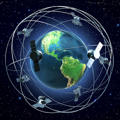
So what is coming? Some day there may be as many as 80 satellites from GPS, GLONASS, GALILEO, QZSS, and others. If so the systems will provide users with a variety of signals and codes. The availability of many more satellites will enable new applications in areas where the current lack of satellites has been a hindrance. For civil users, Personal GPS tracker will provide more protection from interference, ability to compensate for ionospheric delays with pseudoranges, and wide-laning or even trianing capabilities. For military users, there will be greater antijam capability and security. For everybody, there will be improvement in accuracy, availability, integrity, and reliability. It looks as if the GNSS is on its way. So it is no surprise that there is great anticipation from a business perspective, but from a user’s point of view the situation is not unlike the advent of GPS more than 30 years ago. Much is promised but little assured. New capabilities will be available, but exac...

GPS Solution - Differential GPS and real-time kinematic

Image
Most, not all, GPS surveying relies on the idea of differential positioning. The modeof a base or reference receiver at a known location logging data at the same time as a receiver at an unknown location together provide the fundamental info rmation for the determination of accurate coordinates. While this basic approach remains today, the majority of electronic tracking device surveying is not done in the static postprocessed mode just described. Postprocessing is most often applied to control work. Now, the most commonly used methods utilize receivers on reference stations that provide correction signals to the end user via a data link sometimes over the Internet, radio signal, or cell phone and often in real-time. In this category of GPS surveying work there is sometimes a distinction made between code-based, DGPS, and carrier based, RTK, solutions. In fact, most systems use a combination of code and carrier measurements so the distinction is more a matter of emphasis rather than...

Mini Anti-Theft Vehicle GPS Tracker

Image
Car tracking GPS is a practical and easy-to-use GPS tracker specially designed for vehicle tracking. It combines GSM+GPRS+GPS wireless communication technology, with A-GPS function the device can easily achieve extreme fast positioning (Cold start < 10s). Vehicle GPS tracker is ultra-thin, easy to install, maintenance free, built-in high sensitivity GPS chipset and antenna enables it to fast and precise locating even in the concrete jungle. Its built-in 3-axis accelerometer extends battery life through sophisticated power management algorithms. Users can use cell phone, PC or SMS to locate the vehicle’s real-time position and driving paths. Jimi JV200 will provide you high quality vehicle GPS tracking devices based on Jimi’s exceptional technology and standards. This user manual has been specially designed to guide you through the functions and features of your JV200. Please read this manual carefully before using yo|ur device to ensure safe and correct use. The descriptions of ...

GPS Tracking Device for blind individuals

Image
Over the past few years, the electronic tracking device commercial market has grown rapidly. People are using GPS in rental cars, on hiking trips, and in many other recreational activities. Companies have been formed whose business it is to put names on latitude and longitude coordinates. These companies have constructed extensive databases with street names, addresses, business names, points of interest, restaurants, underwater wrecks, and the list goes on. Anything which is stationary is likely to be labelled. All of this extensive data has been put into electronic form so that it can be converted into various computer formats. With this growth in electronic data, blind people no longer need be limited to the small amounts of location information they could previously glean from sighted people. The maps and points of interest are no longer just a drawing on an inaccessible print map. This electronic data can be converted into programs that work on computers designed for blind or v...

Lovely GPS tracker Phone for Kids

Image
Since the introduction of the first consumer GPS receivers in 1995, the metamorphosis of the GPS receiver has been dramatic. The variety of GPS receivers available includes receivers with different connectors (Serial, USB, Compact Flash, etc.), receivers of different sizes (from TV remote size to matchbook size), many different user applications (screens, maps, points of interest files), and so on. So which features are important when constructing a portable tracker for use by Kids? A small sized, lightweight device is important for the accessible GPS package. Durability, price and functionality must be considered when evaluating the tradeoffs with size. Another important issue with GPS receivers is the accuracy reliability. A receiver must work well when there is marginal satellite visibility, for example, in the window of a bus or on the sidewalk close to a tall building. As stated before, the GPS information from the satellites has its limitations, but there are receivers that mo...

GPS devices that include 3G communication chips

Image
With the current technology, tracking and tracing usually requires an additional GPS antenna to determine the precise location, as the position information from the GSM network is too fuzzy to provide accurate location data. Also communication with mobile units is often established by Short Message Service (SMS), with a fixed fee associated with every query. There is no permanent flow of data communications (SMS is not an “always on” service) between the field staff and the base—and every query incurs relevant cost. With the evolvement of 3G networks, there is an expectation of change in the infrastructure or rather; there have already been some changes. 3G will allegedly provide “always on” data communication at high speed, which will enable easy and quick queries at any time, even continuous tracking and tracing. It is also assumed that this service will be at a comparatively lower rate. The major enhancements to be expected from GPS 3G mobile services are directly linked to new k...

Recent innovations in GPS Tracking Device technology

Image
Through the developments of a few decades, GPS is now even known by school children. GPS tracker has been very widely applied in several areas, such as air, sea and land navigation, low earth orbit (LEO) satellite orbit determination, static and kinematic positioning, flight-state monitoring, as well as surveying, etc. GPS has become a necessity for daily life, industry, research and education. GPS receivers are designed with many built-in features but only a few are essential for wilderness navigation. Any feature that requires the receiver to stay switched on for prolonged periods should be used sparingly as conserving battery power is an important consideration, especially in cold weather. Under certain conditions, built-in or optional features can enhance the performance of a GPS receiver. Recent innovations in GPS technology have introduced ways to enhance precision, availability, and reliability in advanced receivers. These innovations address mitigation of multipath errors, r...

Animal biotelemetry is driven by GPS Tracking Device

Image
We are currently seeing a golden age of unprecedented progress and discovery in movement research. The innovation in Global Positioning System (GPS) technology, combined with systems for remote data transfer, has particularly favored tracking device -based animal telemetry to become a standard in wildlife tracking. Three main processes are responsible for this rapid advancement: (1) the development of new tracking techniques to quantify movement, (2) powerful data analysis tools to examine key questions about movement and its causes and consequences, and (3) conceptual and theoretical frameworks for integrating movement research. Many new tools have been developed recently to record the movement of various organisms vii with levels of accuracy, frequency, and duration that are much higher than they were just a few years ago. This has strongly improved our capacity to track insects, fish, and other relatively small organisms. However, arguably the most dramatic development in animal bio...

GPS applications - personal vehicle tracking devices

Image
Understanding the right positions and directions of people and objects is a significant issue from the ancient eras to the present. In the past, people often launched a war in order to satisfy the craving for the dominating powers and spread their realms. In the recent, Global Satellite Positioning System (GPS) has become the one of most popular positioning technologies. GPS can provide users precise positioning information, no matter wherever that may present their own positions. The early GPS positioning technology has been widely used in military, marine use, until recently gradually applied into our daily life, e.g. automotive navigation, geodesy surveying, etc. In this chapter, the authors will briefly introduce some GPS issues including the origins of GPS, GPS system architecture, and related GPS applications. The most driving purpose is to traverse to the destination safely, efficiently, and comfortably. Two types of approaches could achieve the goals, including the static and...

Using GPS Tracking Device will enhance your basic navigational skills

Most GPS receiver cases have a loop on the back to hold the case on a belt. If you’re wearing shorts or tights and don’t have a belt, waist packs for carrying a radio or a cassette/CD player are an option. These packs can accommodate larger GPS receivers. They’re not very noticeable when you’re working out because they’re designed not to bounce much. Small fanny packs and waist packs that carry water bottles also carry a GPS receiver. If the GPS receiver is small, try carrying it in your front pants pocket. I’ve carried a GPS while running and cross-country skiing in trail-running shorts and tights with zipper pockets. Although satellite reception is sometimes lost while under heavy tree cover, the electronic tracker records track data as long as I have a mostly clear view of the sky. Using GPS will greatly enhance your understanding of the map-and-compass technique, but it’s wise to hone basic navigational skills before or in conjunction with use of a Personal GPS tracker . When ou...