Posts

Showing posts with the label Car GPS tracker device

Bus tracking Technology and Thai public transportation

Image
On any given day in Bangkok, Thailand, you can find more than 20,000 buses, minibuses, and vans operating on 470 routes. In a city of 8 million people with another 14 million in the greater Bangkok Metropolitan Region, public transportation is a necessity. Unfortunately, public transportation can also be a great liability.  GPS technology in public transport not only functions as a tracking device. It is also a form of deterrent to unsafe road practices. A bus driver will take more precaution and adopt road safety measures knowing that their vehicular usage is being constantly monitored.   Zero accident in public transportation can come to reality as in the beginning of 2016, Department of Land Transport has enforced all new-registered public transportation, trailers and lorries with 10 wheels or more to install  Vehicle GPS Tracking Device  . All data is linked to Department of Land Transport’s Transport Management Center to accommodate tracking and observe dri...

A great example of AGPS GSM tracking for cargo securities

Most companies have figured out that they need to remove the human factor from the equation as much as possible  The use of web-based monitoring and mobile communication is the impending wave of future products as most security providers are looking for better ways to protect or immobilize the truck and trailer without having to depend on the driver. Covert AGPS systems and mobile communication locking or controlling devices which can be monitored or applied remotely is where the security for the in-transit piece of the transportation industry is heading, especially for high value shipments  In the not too distant future, insurers are going to require this type of technology in return for affordable high value cargo shipment liability insurance coverage. Recently, at the company where I work, we were tracking some very high value shipments going from a Mexico origin to a Canadian destination for a large consumer product company. For this tracking application, we use an AGPS ...

Using Portable GPS Tracker with a PDA

Image
Personal digital assistants (PDAs), such as a Pocket PC or Palm, are a popular way of accessing GPS information. The PDA processes satellite data from a  Portable GPS  and then displays your current location in a mapping program. You can use many different types of GPS receivers with PDAs, including handheld, mouse, wireless, and card. This chapter helps you navigate through the PDA/GPS maze by reviewing the different hardware and software options and comparing common, handheld GPS receivers with PDAs that use GPS. I start things off by discussing some of the advantages and disadvantages of PDA-based navigation systems Choosing between a GPS Receiver and a PDA.   You might wonder why anyone would you want to use a PDA instead of a handheld, consumer GPS receiver. That’s a very good question; you gadget junkies out there who have your hands raised and are answering, “Because it’s cool,” please put your hands down and continue reading. You’ll find compelling advantages...

High Sensitivity - Indoor GPS Tracking Devices

Image
We are now ready to exploit all this knowledge to study the design of A-GPS receivers that have much greater sensitivity than standard  GPS Tracking Device  . If you are designing a high-sensitivity receiver, then it is essential to understand the relationship of these signals to each other and the effects of each of the receiver components on the signal. Once you understand the processing gain of each part of the receiver, then it is a small step to understand how to increase that gain and thus increase the sensitivity of the receiver. However, even if you are not designing a receiver, it is still important to understand the relationship of the signal strength at the antenna to the correlation response. This is because the measure of a high sensitivity receiver is its ability to acquire and track weak signals. The only way of knowing how weak the signals actually are, in practice, is for the receiver to tell you, and the way the receiver knows is by back-calculating the sign...

GPS gives people a method for both assigning and using absolute coordinates

Image
IN WHICH you are introduced to facts and concepts relating to the NAVSTAR Global Positioning System and have your first experience using a  electronic tracking devices   .  A sports club in Seattle decided to mount a hunting expedition. They employed a guide who came well recommended, and whose own views of his abilities were greater still. Unfortunately, after two days, the group was completely, totally lost. “You told me you were the best guide in the State of Washington,” fumed the person responsible for hiring the guide. “I am, Iam” claimed the man defensively. “But just now I think we’re in Canada.” Stories like the one above should be told now (if at all), before they cease to be plausible. Actually, even at present, given the right equipment and a map of the general area, you could be led blindfolded to any spot in the great out-of-doors and determine exactly where you were. This happy capability is due to some ingenious electronics and a dozen billion dollars...

Downconverter is very helpful for vehicle GPS tracking systems

Image
In order to design and build a GPS receiver, the developer must understand the basic functional blocks that comprise the device, and the underlying hardware and software necessary to implement the desired capabilities. The sections below describe the main functional blocks of a GPS receiver, and the types of solutions that are either available today or in development to provide that functionality. The demand for the integration of positioning technology into smaller devices is challenging antenna development. The industry is already pushing for smaller antennas for applications such as a wristwatch with integrated GPS, which is smaller than most patch antennas available today. Another demand is for dual-purpose antennas that do double duty in wireless communication devices, such as in a mobile telephone with an integrated GPS receiver. Inevitably, the future will bring smaller and more flexible antennas for  GPS Tracking Device  . The function of the downconverter is to s...

Additional tracking device augmentation techniques

Image
Additional techniques are being developed for increasing the accuracy of the positioning information derived from the GPS for certain applications. One technique, which has been developed by the US Federal Aviation Administration (FAA), uses transmissions from communication satellites to improve the positioning accuracy of GPS tracking device in aircraft. This technique, known as the wide area augmentation system (WAAS), uses a network of wide area ground reference stations (WRS) and two wide area master stations (WMS) to calculate pseudorange correction factors for each SV, as well as to monitor the operational health of each SV. This information is uplinked to communication satellites in geostationary earth orbit (GEO), which transmit the information on the L1 frequency, along with additional ranging signals. This system has improved the positioning accuracy of GPS on board aircraft to within 7 metres horizontally and vertically, allowing the system to be used by aircraft for Catego...

Car GPS tracker in the intelligent transportation space

Image
There is no doubt that one of the most important enabling technologies in the intelligent vehicle space is the global positioning system (GPS). Without the ability accurately to determine a vehicle’s position on demand, there would be no way to cost-effectively implement autonomous or server-based vehicle navigation, nor would the ability to deliver customized, location-based services to the vehicle be possible. This chapter will provide a brief overview of the History of GPS. Long before the development of the Car tracking GPS in use today, the concept of time transfer and positioning via signals from space was being researched around the world. These costly research projects were mainly sponsored by government agencies, to address their long-standing need to improve techniques for quickly and accurately positioning military vehicles and personnel on or above the battlefield. Troops and vehicles of centuries past relied on maps, charts, the stars and various electronic devices to f...

GPS Solution - Differential GPS and real-time kinematic

Image
Most, not all, GPS surveying relies on the idea of differential positioning. The modeof a base or reference receiver at a known location logging data at the same time as a receiver at an unknown location together provide the fundamental info rmation for the determination of accurate coordinates. While this basic approach remains today, the majority of electronic tracking device surveying is not done in the static postprocessed mode just described. Postprocessing is most often applied to control work. Now, the most commonly used methods utilize receivers on reference stations that provide correction signals to the end user via a data link sometimes over the Internet, radio signal, or cell phone and often in real-time. In this category of GPS surveying work there is sometimes a distinction made between code-based, DGPS, and carrier based, RTK, solutions. In fact, most systems use a combination of code and carrier measurements so the distinction is more a matter of emphasis rather than...

Mini Anti-Theft Vehicle GPS Tracker

Image
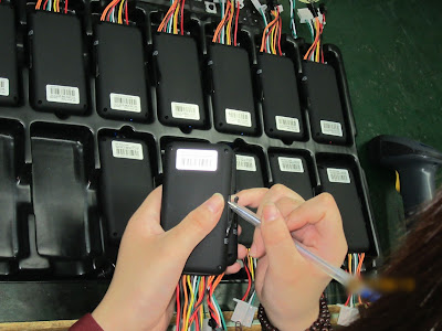
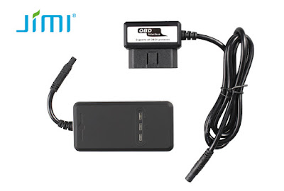
Car tracking GPS is a practical and easy-to-use GPS tracker specially designed for vehicle tracking. It combines GSM+GPRS+GPS wireless communication technology, with A-GPS function the device can easily achieve extreme fast positioning (Cold start < 10s). Vehicle GPS tracker is ultra-thin, easy to install, maintenance free, built-in high sensitivity GPS chipset and antenna enables it to fast and precise locating even in the concrete jungle. Its built-in 3-axis accelerometer extends battery life through sophisticated power management algorithms. Users can use cell phone, PC or SMS to locate the vehicle’s real-time position and driving paths. Jimi JV200 will provide you high quality vehicle GPS tracking devices based on Jimi’s exceptional technology and standards. This user manual has been specially designed to guide you through the functions and features of your JV200. Please read this manual carefully before using yo|ur device to ensure safe and correct use. The descriptions of ...

Vehicle GPS tracking devices - About Vehicle-to-Vehicle communication

Image
Direct communication between vehicles allows information exchange without requiring any fixed infrastructure or base stations. The location and velocity of vehicles is constantly changing, and the RF communication range is of fairly short distance; therefore, the set of vehicles that can directly communicate will constantly change over a short period of time. This dictates that the physical layer and the network must be capable of operating in an ad hoc, decentralized manner, although coordination and synchronization through GPS ( GPS tracker ) time signals are possible. Any two nodes must be able to communicate securely whenever they are within communication range. In a V2V network we can distinguish two modes of communication, usually designated as: • Single hop: Two vehicles are close enough to communicate directly with each other (either broadcast or point to point) with low latency. • Multihop: Vehicles that can not directly communicate may forward messages through interme...

Integration of Car tracking GPS with mapping program Assistance

Image
GPS Visualizer is a slick, easy-to-use Web-based mapping program, written by Adam Schneider, that allows you to upload GPS waypoints and track files to a Web site and then overlay them on topographic and other types maps. GPS Visualizer relies on online sources that provide free topographic maps, aerial photos, satellite images, and street maps. Unlike many other sites that are limited to making maps of the United States, GPS Visualizer can create maps of Canada, Europe, and other places in the world. GPS Visualizer has a number of powerful options for creating customized maps. In this section, I describe how to make a map using some of the Web site’s basic features. After you master the general procedure, you can experiment on your own with some of the other advanced options. Map aiding is most useful when map matching has determined that the vehicle has just turned a corner, in which case its position is in close proximity to the intersection of two streets of a known location in t...

Personal vehicle tracking devices and Map Databases

Image
One major challenge with map matching before electronic tracker was available was the initialization of the system when the starting position was not known. In early navigation systems, the user sometimes had to be prompted to enter the current position. Of course this was difficult if the user did not know where they were! With GPS, the absolute position is readily determined, and, in time, GPS receivers were added to navigation systems. Initially, GPS was only used to get the DR/map matching system started or to detect large errors. Then systems emerged where the GPS/DR trace was compared with the digital road map in order to find the most probable location of the vehicle. Today, most navigation systems rely primarily on GPS and use DR and map matching to correct GPS errors and bridge the coverage gaps. A robust map matching implementation uses confidence measures to determine all possible road segments in the map on which the vehicle could be traveling. In order to support map ma...

Vehicle GPS tracking device is sufficient for some safety applications

Image
A Global Positioning System (GPS) is a key component of a present day intelligent vehicle. tracker for vehicle can be used to find absolute position and velocity. This is very useful for an autonomous vehicle that has access to a precise map, as it can understand where it is with respect to its destination and with respect to the road network or, for an off-road vehicle, topographic features and obstacles. This information is needed, for example, to compute optimal routes or driving directions. On- or offroad, when combined with a vehicle-to-vehicle wireless communication system, it can also provide relative position and relative speed information. Autonomous vehicles use all the standard sensors available in a car for self-sensing. Thus speed sensing is available, and variables that are measured in the engine and powertrain or are related to the brakes can be accessed. Furthermore, sensors are needed to measure steering wheel angle and gear shift, but these are fairly easy to desig...

GPS applications - personal vehicle tracking devices

Image
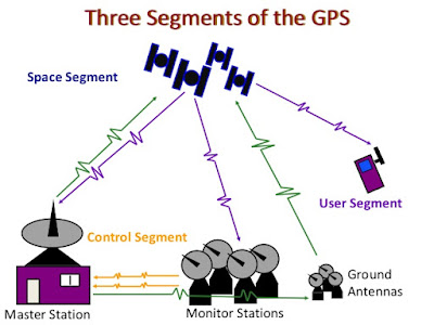
Understanding the right positions and directions of people and objects is a significant issue from the ancient eras to the present. In the past, people often launched a war in order to satisfy the craving for the dominating powers and spread their realms. In the recent, Global Satellite Positioning System (GPS) has become the one of most popular positioning technologies. GPS can provide users precise positioning information, no matter wherever that may present their own positions. The early GPS positioning technology has been widely used in military, marine use, until recently gradually applied into our daily life, e.g. automotive navigation, geodesy surveying, etc. In this chapter, the authors will briefly introduce some GPS issues including the origins of GPS, GPS system architecture, and related GPS applications. The most driving purpose is to traverse to the destination safely, efficiently, and comfortably. Two types of approaches could achieve the goals, including the static and...

Using GPS Tracking Device will enhance your basic navigational skills

Most GPS receiver cases have a loop on the back to hold the case on a belt. If you’re wearing shorts or tights and don’t have a belt, waist packs for carrying a radio or a cassette/CD player are an option. These packs can accommodate larger GPS receivers. They’re not very noticeable when you’re working out because they’re designed not to bounce much. Small fanny packs and waist packs that carry water bottles also carry a GPS receiver. If the GPS receiver is small, try carrying it in your front pants pocket. I’ve carried a GPS while running and cross-country skiing in trail-running shorts and tights with zipper pockets. Although satellite reception is sometimes lost while under heavy tree cover, the electronic tracker records track data as long as I have a mostly clear view of the sky. Using GPS will greatly enhance your understanding of the map-and-compass technique, but it’s wise to hone basic navigational skills before or in conjunction with use of a Personal GPS tracker . When ou...

Causes of electronic tracking devices position errors

Image
Technology has drastically advanced and unlike the past when people needed a special satellite GPS receiver to track movements, today the GPS trackers are found in smart phones and other small gadgets. They work by connecting to the internet connection as well as receiving a signal directly from the GPS satellite, which helps pinpoint the exact location of the GPS signal. This has proven to be a truly important tool for automobile owners since the Asset GPS tracker can be installed in a secret location on a vehicle allowing security personnel to track the signal from the vehicle and locate the vehicle. Now the vehicle GPS tracking device needs to determine the time part of the formula. The answer lies in the coded signals the satellites transmit. The transmitted code is called “pseudo-random code” because it looks like a noise signal. When a satellite is generating the pseudo-random code, the personal tracking device is generating the same code and tries to match it up to the satel...

There are various kinds of GPS Tracking Device flooding the market in the recent times

Image
Ancient travelers relied on celestial objects, such as stars, to find their way. GPS users also use celestial objects—satellites—to navigate. There are, of course, vast differences between a star and an earth-orbiting man-made object. You observe a star to navigate; a satellite is invisible to the naked eye, but you use its position data, or ephemera, to navigate. Modern navigators no longer have to wait for nightfall and clear skies, and, thanks to atomic clocks, they can receive precise position data continuously. According to the National Academy of Sciences, in 1957 scientists observing the newly launched Sputnik realized they could predict its position by measuring the increase and decrease in frequency of its radio signal as it orbited the earth. This observation confirmed that a satellite’s position in space could be accurately determined from the ground, which meant a satellite could determine the accurate position of an object on or above the ground, such as a hiker or a hang ...

How GPS Works —— The secrets of Magnetic GPS

Image
It’s fun to uncover something that you aren’t supposed to know about — many software applications and movies on DVD contain what are known as “easter eggs.” However, imagine finding something that you aren’t supposed to find that turns out to be useful and informative. In this article, we are going to hunt for GPS easter eggs, delving into the secrets that lie behind the standard menus on your GPS unit to find useful features and diagnostic screens that can give you information about your system and troubleshoot problems that you might have. There’s a lot of information to find — technical information, diagnostic information, and more. Let’s begin our tour of the secrets of Magnetic GPS . How GPS Works The basic principle behind GPS is straightforward: The GPS receiver picks up a signal from three or more of the satellites and then uses this information to calculate the distance to the satellites. This information is, in turn, used to determine a location on the globe where th...

Hidden Secrets of GPS Tracking Device

Image
A BRIEF HISTORY PRIOR TO atomic clocks, quartz-movement watches kept the most accurate time. Quartz time, based on the vibrations of a quartz crystal, is accurate to about one thousandth of a second perday. But with radio signals traveling at the speed of light, a clock that is off by even a thousandth of a second will produce a gross position error. Atomic clocks, accurate to within 1 second every 100,000 years, derive their precision from the highly predictable gains and losses of energy by atoms. These clocks, accurate to a billionth of a second, are key to the success of GPS. Ancient travelers relied on celestial objects, such as stars, to find their way. GPS users also use celestial objects—satellites—to navigate. There are, of course, vast differences between a star and an earth-orbiting man-made object. You observe a star to navigate; a satellite is invisible to the naked eye, but you use its position data, or ephemera, to navigate. Modern navigators no longer have to wait ...