Posts

Showing posts with the label Vehicle GPS Tracking Device

Performance considerations for electronic tracking devices

Image
There are many parameters used by the industry to assess the performance of a GPS receiver, and to evaluate the relative performance of comparable receivers. The most common parameters being used to evaluate GPS receiver performance include positioning and timing accuracy, time-to-first-fix, reacquisition time, and receiver sensitivity. Positioning and timing accuracy The most obvious of these parameters is positioning accuracy – how accurate are the positions calculated by an autonomous GPS receiver, based on the number of satellites that can be seen by that receiver? This is typically measured by performing a mapmatching test, where positions calculated by a receiver for landmarks on a map are compared to their known positions. This is a standard test that is often used to compare the accuracy of multiple GPS receivers simultaneously. When the S/A feature was still enabled, the accuracy of the SPS signal served as the baseline for positioning accuracy for commercial GPS rece...

System level solutions for GPS tracker

Image
When access to the GPS first became available for military and commercial use, only a few companies had the technology and expertise to develop reliable, accurate  GPS Tracking Device  . Application developers who needed GPS services would simply purchase a board level solution from a GPS supplier, and integrate it into their design. In the past, GPS correlators were designed with a single channel, which was multiplexed between each SV signal being received. This resulted in a very slow process for calculating a position solution. Today, systems come with up to 12 channels, allowing the correlator to process multiple SV signals in parallel, achieving a position solution in a fraction of the time. Also, while the correlator functionality is sometimes performed in software using a high-performance digital signal processor (DSP), the real-time processing requirements and repetitive high rate signals involved make a hardware correlator solution ideal, from both a cost and through...

GPS tracking device for cars – Intelligent Vehicle Technologies

Image
The navigation message The navigation message broadcast by every GPS satellite contains a variety of information used by each tracking platform to calculate a PVT solution. The information in this message includes time of signal transmission, clock correction and ephemeris data for the specific SV, and an extensive amount of almanac and additional status and health information on all of the satellites in the GPS. Each SV repeatedly broadcasts a navigation message that is 12.5 minutes in length,and consists of 25 1500-bit data frames transmitted at 50 bits per second. A single data frame is composed of five 300-bit subframes, each containing different status or data information for the receiver, preceded by two 30-bit words with SV-specific telemetry and handover information. The first three subframes, containing clock correction and ephemeris data relevant to the specific SV, are refreshed as necessary for each data frame transmitted during the navigation message broadcast. The al...

Car GPS tracker in the intelligent transportation space

Image
There is no doubt that one of the most important enabling technologies in the intelligent vehicle space is the global positioning system (GPS). Without the ability accurately to determine a vehicle’s position on demand, there would be no way to cost-effectively implement autonomous or server-based vehicle navigation, nor would the ability to deliver customized, location-based services to the vehicle be possible. This chapter will provide a brief overview of the History of GPS. Long before the development of the Car tracking GPS in use today, the concept of time transfer and positioning via signals from space was being researched around the world. These costly research projects were mainly sponsored by government agencies, to address their long-standing need to improve techniques for quickly and accurately positioning military vehicles and personnel on or above the battlefield. Troops and vehicles of centuries past relied on maps, charts, the stars and various electronic devices to f...

Using tracking device for logistics information management system

Image
The electronic tracker can be quickly given the position and velocity, but not to The target property of their geographical environment and spatial information associated with a description ,while the GIS is just to meet the requirements of this complementarily. Obviously, if only isolated the point of location information without geographic reference and other supporting information required, point position information on the application of logistics management is not very meaningful. With an electronic map(GIS technology) car, keep the city urban area map and save it up. It is accuracy and the amount of the information can be much higher than the printing of the urban traffic plan, but the car location achieved by drivers with the scene around by. Adding a portable GPS tracking, car location, driving direction, speed and other information can be displayed at any time in the electronic map.In short, using GPS and GIS technology in logistics information management system can use the G...

Vehicle GPS Tracking Device and Navigation Systems

Image
Since the first generation GPS chip was presented to the public, it overcomes some problems: unclear signal of ex-chip, long positioning time, location drifting, etc. Due to the progress of chip manufacturing procedure and size reduction, even PDA, digital camera, cell phone and so on can be integrated with GPS. The personal vehicle tracking devices equipped on the vehicles is simple and more accuracy than dead reckoning method. It is getting to be used as basic vehicle equipment. Conversely, some disadvantages of GPS still need to be addressed. For example, if a cell phone or radio’s wave band is closed to GPS’, it would cause interference. In addition, tunnels and weather would affect the accuracy of GPS also. Thus, adjusting GPS error by a fixed base station and then conveying it to the vehicles’ GPS for correcting can add accuracy. It is called Differential GPS (namely D-GPS). The FM radio can also receive the positioning signal from the base station. Vehicle Tracking The GPS ...

Mini Anti-Theft Vehicle GPS Tracker

Image
Car tracking GPS is a practical and easy-to-use GPS tracker specially designed for vehicle tracking. It combines GSM+GPRS+GPS wireless communication technology, with A-GPS function the device can easily achieve extreme fast positioning (Cold start < 10s). Vehicle GPS tracker is ultra-thin, easy to install, maintenance free, built-in high sensitivity GPS chipset and antenna enables it to fast and precise locating even in the concrete jungle. Its built-in 3-axis accelerometer extends battery life through sophisticated power management algorithms. Users can use cell phone, PC or SMS to locate the vehicle’s real-time position and driving paths. Jimi JV200 will provide you high quality vehicle GPS tracking devices based on Jimi’s exceptional technology and standards. This user manual has been specially designed to guide you through the functions and features of your JV200. Please read this manual carefully before using yo|ur device to ensure safe and correct use. The descriptions of ...

GPS tracking solutions - About GPS Surveying Techniques

Image
If a static tracking device control survey is carefully planned, it usually progresses smoothly. The technology has virtually conquered two stumbling blocks that have defeated the plans of conventional surveyors for generations. Inclement weather does not disrupt GPS observations, and a lack of intervisibility between stations is of no concern whatsoever, at least in postprocessed GPS. Still, electronic tracking devices is far from so independent of conditions in the sky and on the ground that the process of designing a survey can now be reduced to points-per-day formulas, as some would like. Even with falling costs, the initial investment in GPS remains large by most surveyors’ standards. However, there is seldom anything more expensive in a GPS project than a surprise. New Design Criteria These upgrades in accuracy standards not only accommodate control by static GPS; they also have cast survey design into a new light for many surveyors. Nevertheless, it is not correct to say th...

Integration of Car tracking GPS with mapping program Assistance

Image
GPS Visualizer is a slick, easy-to-use Web-based mapping program, written by Adam Schneider, that allows you to upload GPS waypoints and track files to a Web site and then overlay them on topographic and other types maps. GPS Visualizer relies on online sources that provide free topographic maps, aerial photos, satellite images, and street maps. Unlike many other sites that are limited to making maps of the United States, GPS Visualizer can create maps of Canada, Europe, and other places in the world. GPS Visualizer has a number of powerful options for creating customized maps. In this section, I describe how to make a map using some of the Web site’s basic features. After you master the general procedure, you can experiment on your own with some of the other advanced options. Map aiding is most useful when map matching has determined that the vehicle has just turned a corner, in which case its position is in close proximity to the intersection of two streets of a known location in t...

Personal vehicle tracking devices and Map Databases

Image
One major challenge with map matching before electronic tracker was available was the initialization of the system when the starting position was not known. In early navigation systems, the user sometimes had to be prompted to enter the current position. Of course this was difficult if the user did not know where they were! With GPS, the absolute position is readily determined, and, in time, GPS receivers were added to navigation systems. Initially, GPS was only used to get the DR/map matching system started or to detect large errors. Then systems emerged where the GPS/DR trace was compared with the digital road map in order to find the most probable location of the vehicle. Today, most navigation systems rely primarily on GPS and use DR and map matching to correct GPS errors and bridge the coverage gaps. A robust map matching implementation uses confidence measures to determine all possible road segments in the map on which the vehicle could be traveling. In order to support map ma...

About GPS phone and how to select a GPS tracker

Image
GPS will play a large role in the future of cellphones. The U.S. government has mandated that calls placed by cellphones to 911 emergency operators must reveal where the call was made, just like landline telephones. This new program works by either triangulating a mobile phone’s position via cellular phone network antenna towers or with a GPS receiver built into the cellphone that transmits its location. In 2003, the first GPS ID Card enabled cellular phones started to appear on the U.S. market. Internet sites and tracking software are available that can provide you with the location of a GPS-enabled phone that’s subscribed to a location reporting service. As GPS phone start to become more common, it’s only a matter of time before navigation and map programs start to appear on the phones, which will bring a whole new meaning to using your phone to get directions. Trying to decide which GPS unit and accessories to get could be overwhelming, especially with the number of choices...

Causes of electronic tracking devices position errors

Image
Technology has drastically advanced and unlike the past when people needed a special satellite GPS receiver to track movements, today the GPS trackers are found in smart phones and other small gadgets. They work by connecting to the internet connection as well as receiving a signal directly from the GPS satellite, which helps pinpoint the exact location of the GPS signal. This has proven to be a truly important tool for automobile owners since the Asset GPS tracker can be installed in a secret location on a vehicle allowing security personnel to track the signal from the vehicle and locate the vehicle. Now the vehicle GPS tracking device needs to determine the time part of the formula. The answer lies in the coded signals the satellites transmit. The transmitted code is called “pseudo-random code” because it looks like a noise signal. When a satellite is generating the pseudo-random code, the personal tracking device is generating the same code and tries to match it up to the satel...

About tracking device - various types of GPS receivers

Image
In this highly competitive world, any business can survive and grow only if it’s ready to accept changes and adapt to new technology. Online vehicle tracking is one such innovative service that will add a lot of value to your services. GPS tracking provides numerous benefits that help increase revenue. These include reduced fuel costs, lower insurance premiums, increased productivity, improved dispatching, and back office efficiencies. For the driver, all these benefits add to job security with a financially stable company. Saving money on fuel alone over the course of the year can potentially equal to an entire salary for one employee. Increased revenue can also be forwarded to employees in the form of bonuses. Rewards based on data collected from GPS tracking can boost morale and help gain acceptance of the system. Employees should know that while it may be new to your business, personal tracking device is rapidly becoming the industry standard for any business with a fleet of vehic...

GPS Tracking Solution —— how to use GPS tracker

Image
Need directions? Are you good at getting lost? Then GPS is just the technology you’ve dreamed of. If you have a personal tracking device or plan to buy one, this blog helps you compare GPS technologies,units, and uses. You’ll find out how to create and use digital maps and learn about waypoints, tracks, coordinate systems,and other key point to using GPS technology. Get more from your GPS device by learning to use GPS tracking platform and even how to turn your cell phone or PDA into a GPS receiver. You’ll also discover: Up-to-date information on the capabilities of popular handheld and automotive Global Positioning Systems How to read a map and how to get more from the free maps available online The capabilities and limitations of GPS technology, and how satellites and radio systems make GPS work How to interface your waterproof tracking devices with your computer and what digital mapping software can offer Why a cell phone with GPS capability isn’t the same as a GPS unit What can...

Use Vehicle GPS locator to Save Your Money

Image
A short history of GPS Military, government, and civilian users all over the world rely on GPS for navigation and location positioning, but radio signals have been used for navigation purposes since the 1920s. LORAN (Long Range Aid to Navigation), a position-finding system that measured the time difference of arriving radio signals, was developed during World War II. The first step to GPS came way back in 1957 when the Russians launched Sputnik, the first satellite to orbit the Earth. Sputnik used a radio transmitter to broadcast telemetry information. Scientists at the Johns Hopkins Applied Physics Lab discovered that the Doppler shift phenomenon applied to the spacecraft — and almost unwittingly struck gold. A down-to-earth, painless example of the Doppler shift principle is when you stand on a sidewalk and a police car speeds by in hot pursuit of a stolen motorcycle. The pitch of the police siren increases as the car approaches you and then drops sharply as it moves away. Americ...

Why should you need a GPS tracking device for outdoor

Image
What’s my favorite outdoor activity? Although I enjoy riding my mountain bike to work, what really turns me on is diving into a patch of thick woods and getting completely lost. If it’s an area I’m familiar with, all I need is a water bottle, an energy bar, and a hat in case I’m out after dark. So why would I buy a GPS tracker ? Because they’re small, they’re relatively inexpensive, and they provide the biggest tax-dollar bang-for-the-buck that I can imagine. When I switch on the GPS, I’m plugging into a multibillion-dollar satellite-based navigation system that is coddled in some manner by several of the largest and most powerful U.S. government agencies, including all branches of the military beneath the wings of the Department of Defense and the Department of Transportation. It’s almost irresistible once you realize the enormity of what a simple $150 cell phone–size device can do A GPS unit, coupled with inexpensive topographic-map software, allows you to preview your excursion, ...

About High Accuracy Personal Portable GPS Tracker

Image
GPS - the Global Positioning System - is a navigation revolution. It’s a technology that pinpoints a user’s location anywhere in the world, 24 hours a day, regardless of the weather. Designed by the United States’ Department of Defense for use by the military, the GPS System was made available to civilians for use in aviation, marine surveying and general outdoor/recreation markets. Today, millions of people utilize the accuracy and convenience of this amazing technology to hunt, fish, hike, fly, cruise and sail. GPS consists of a constellation of 24 satellites orbiting some 12,000 miles above the earth. These satellites transmit signals containing time and orbital data to calculate satellite position and almanac data. Meanwhile, receivers used on the ground, sea and air search the sky for the satellites. The GPS unit needs to acquire good signals from at least three satellites to determine a position on the surface of the earth. A fourth signal is required to get three-dimensional pos...

Hidden Secrets of GPS Tracking Device

Image
A BRIEF HISTORY PRIOR TO atomic clocks, quartz-movement watches kept the most accurate time. Quartz time, based on the vibrations of a quartz crystal, is accurate to about one thousandth of a second perday. But with radio signals traveling at the speed of light, a clock that is off by even a thousandth of a second will produce a gross position error. Atomic clocks, accurate to within 1 second every 100,000 years, derive their precision from the highly predictable gains and losses of energy by atoms. These clocks, accurate to a billionth of a second, are key to the success of GPS. Ancient travelers relied on celestial objects, such as stars, to find their way. GPS users also use celestial objects—satellites—to navigate. There are, of course, vast differences between a star and an earth-orbiting man-made object. You observe a star to navigate; a satellite is invisible to the naked eye, but you use its position data, or ephemera, to navigate. Modern navigators no longer have to wait ...

Application in Different Commercial Field of the Vehicle Tracking

Image
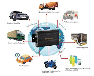
What is commercial vehicle? It can be defined as "any motorized road vehicle which by its type of construction and equipment is designed for, and capable of, transporting, whether for payment or not more than nine person, including the driver; or goods". Therefore, trucks, coaches, buses, vans and trailers are categorised as commercial vehicles. As a result of advances in the automotive industry, commercial vehicles have become more advances in technology and hence, reliability of individual critical components is an important factor for improving the overall reliability and quality of the vehicle. Thus the vehicle tracking system occured. These systems can enhance the security and efficiency of commercial vehicle operations. By closely tracking vehicles and asserts, opportunities for cargo and vehicle theft can be reduced, and dangerous goods can be given added security. What is the meaning of commercial vehicle tracking system? In brief, the behavior that tr...

Explanation for Frequent Misunderstandings of Portable GPS Tracker for Car

Image
Portable GPS tracker for car has beeen used for several decades and it brought many benefits to our life and work. When we communicate with our customers, we find that people has much miss understanding to portable GPS tracker for car, although the management systems are on the rise, but still there are some mistakes which distort the market. Once you, as well as your employees understand that GPS tracking is intended to benefit your company from the bottom up, you will be on the right path for a strong and profitable future. First, many people can not accept GPS tracking device for their car, just we usually called it portable GPS tracker for car in Jimilab, some people feel their privacy is being breached, but you need to know that mainly function of portable GPS tracker for car is not monitoring but provides greater driver safety, when you install this GPS tracking device in your cars or vehicles, you are in a more efficient and safe work environment, it means that y...