Posts

Showing posts from April, 2016

GPS Solution - How to increase the accuracy of your location

Image
Calibration Electronic compasses need to be calibrated whenever you change batteries. If your  GPS Tracking Device  has an electronic compass, follow your user guide’s instructions to calibrate it. Usually, this requires being outside, holding the GPS unit flat and level, and slowly turning in a circle twice. Altimeter The elevation or altitude calculated by a GPS receiver from satellite data isn’t very accurate. Because of this, some GPS units have altimeters, which provide the elevation, ascent/descent rates, change in elevation over distance or time, and the change of barometric pressure over time. (The rough-and-ready rule is that if barometric pressure is falling, bad weather is on the way; if it’s rising, clear weather is coming.) Calibrated and used correctly, barometric altimeters can be accurate within 10 feet of the actual elevation. Knowing your altitude is useful if you have something to reference it to, such as a topographic map. Altimeters are useful...
Electronic tracking devices Positioning techniques

Image
Several different techniques have been developed for using the  GPS tracker  to pinpoint a user’s position, and to refine that positioning information though a combination of GPS derived data and additional signals from a variety of sources. Some of the more popular techniques, such as autonomous positioning, differential positioning and server-assisted positioning, are briefly described below. Autonomous GPS positioning Autonomous positioning, also known as single-point positioning, is the most popular positioning technique used today. It is the technique that is commonly thought of when a reference to using the GPS to determine the location of a person, object or address is made. In basic terms, autonomous positioning is the practice of using a single GPS receiver to acquire and track all visible GPS satellites, and calculate a PVT solution. Depending upon the capabilities of the system being used and the number of satellites in view, a user’s latitude, longitude, a...

GPS tracking solutions - the basic science behind GPS

Image
Fundamentals of satellite-based positioning To understand the true value and cost of the positioning capabilities of the GPS, it is important for the user to have a basic understanding of the science behind positioning, and the types of components and techniques that may be used to calculate accurate positions. The basic science behind GPS; the different unassisted and assisted position calculation techniques that may be used, depending upon the needs of the specific application; and the hardware and software components necessary for calculating a position. The basic science of global positioning The design of the  electronic tracking devices  makes it an all-weather system whereby users are not limited by cloud cover or inclement weather. Broadcasting on two frequencies, the GPS provides sufficient information for users to determine their position, velocity and time with a high degree of accuracy and reliability. As mentioned previously, frequency L1 is generally...

GIS/GPS/GSM-based system for ambulance management

Image
In terms of “integration,” GNSS services can be exploited as a building block for dedicated emergency networks. A representative example for this is the SAR service of GALILEO, which integrates the GNSS with the emergency COSPAS-SARSAT system. Other examples have been reported, such as a GIS/GPS/GSM-based system for ambulance management and emergency incident handling in the Greek prefecture of Attica. The integrated system is expected to operate in the National Center of Immediate Assistance (ETAK in Greek), which deals with emergency medical incidents by coordinating and routing ambulances to appropriate hospitals and offering medical care to patients during their transport to hospitals.  A further system, the Taiwan E-Vanguard for Emergency (EVE), provides help in rescue and first-aid work in rescue operations. EVE consists of rescuers equipped with wearable PDAs, medics with laptops plus GPS, a rescue command center controlled by leaders of rescue and medical teams, and a ...

Some figures of tracking device penetration in various markets

Image
During the last few years the GNSS industry has seen continuous growth in the number of firms that use satellite navigation to create value-added services, ranging from GIS and land surveys to LBS and ITS. This trend toward the provision of consumer services was forecast in many studies carried out in the 1990s, later confirmed by recent research (mainly before selective availability was deactivated). It was reported that in terms of revenues, the aviation market for  GPS tracking device  had a growth of 10%, the marine market 11%, the military and timing markets both just under 25%, and the land market just over 24%. Approximately 62% of the total North American GPS market revenue was from land applications. With the turning off of SA the improved accuracy has encouraged the implementation of new navigation services. A further shift toward service provision is due to the modernization of portable tracker and the European navigation activities, with the introduction of EG...

GPS Tracking Solution - Basic GPS Receiver Features

Image
A number of GPS receivers are on the market. Usually a GPS receiver with more features costs more. GPS manufacturers have done a pretty good job making user interfaces easy to use. After you know the basic concepts of GPS receivers and are familiar with a manufacturer’s user interface, a electronic tracker is usually as easy to use as a cellphone and easier to use than a personal computer. Display and output GPS receivers have three choices for information display or data output: Monochrome LCD screen: Most GPS receivers have a monochrome liquid crystal display (LCD) screen. Color screen: These are especially useful for displaying maps. Color screens usually have shorter battery lives than monochrome ones. No screen: Some GPS receivers only transmit data through an expansion slot or a cable; a receiver with a cable is often called a mouse GPS receiver because it resembles a computer mouse. Such receivers are designed to interface with a laptop computer or PDA running specia...

Errors that Can Affect Tracking Device Tracking Data

Image
The following are some of the main errors that can potentially affect data acquired from GPS sensors (points 1 to 5), and that can be classified as GPS location bias, i.e. due to a malfunctioning of the GPS sensor that generates locations with low accuracy (points 6 to 9): 1. Missing records. This means that no information (not even the acquisition time) has been received from the sensor, although it was planned by the acquisition schedule. 2. Records with missing coordinates. In this case, there is a  electronic tracking devices  failure probably due to bad GPS coverage or canopy closure. In this case, the information on acquisition time is still valid, even if no coordinates are provided. This corresponds to ‘fix rate’ error. 3. Multiple records with the same acquisition time. This has no physical meaning and is a clear error. The main problem here is to decide which record (if any) is correct. 4. Records that contain different values when acquired using d...

GPS tracking device for cars – Intelligent Vehicle Technologies

Image
The navigation message The navigation message broadcast by every GPS satellite contains a variety of information used by each tracking platform to calculate a PVT solution. The information in this message includes time of signal transmission, clock correction and ephemeris data for the specific SV, and an extensive amount of almanac and additional status and health information on all of the satellites in the GPS. Each SV repeatedly broadcasts a navigation message that is 12.5 minutes in length,and consists of 25 1500-bit data frames transmitted at 50 bits per second. A single data frame is composed of five 300-bit subframes, each containing different status or data information for the receiver, preceded by two 30-bit words with SV-specific telemetry and handover information. The first three subframes, containing clock correction and ephemeris data relevant to the specific SV, are refreshed as necessary for each data frame transmitted during the navigation message broadcast. The al...

Car GPS tracker in the intelligent transportation space

Image
There is no doubt that one of the most important enabling technologies in the intelligent vehicle space is the global positioning system (GPS). Without the ability accurately to determine a vehicle’s position on demand, there would be no way to cost-effectively implement autonomous or server-based vehicle navigation, nor would the ability to deliver customized, location-based services to the vehicle be possible. This chapter will provide a brief overview of the History of GPS. Long before the development of the Car tracking GPS in use today, the concept of time transfer and positioning via signals from space was being researched around the world. These costly research projects were mainly sponsored by government agencies, to address their long-standing need to improve techniques for quickly and accurately positioning military vehicles and personnel on or above the battlefield. Troops and vehicles of centuries past relied on maps, charts, the stars and various electronic devices to f...

Magnetic GPS Tracker With Super Long Standby Time

Image
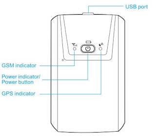
GPS magnetic tracker is extremely easy and flexible to install using strong magnetic design. IP65 protection allows it to operate even in extreme working environment. With large built-in battery, the device is suitable for asset tracking, vehicle tracking, cargo tracking, race motorcycle tracking, etc. Install 1. Please use a GSM SIM card. 2. SIM card in the device should be enabled for GPRS. 3. Caller ID of the SIM card in the device should be on. Warning: Please turn off the device before removing the SIM card. It is forbidden to install or remove the SIM card while the power is on, otherwise the SIM card may be damaged. Charge the battery When the red LED on the device starts to flash quickly, the battery should be charged. Please remember to charge it before the first use. The charging process will take about 4-6 hours. The device can work normally during charging. Red LED being light indicates that it is charging. When charging is finished, red LED will flash slowly. War...